EAST CENTRAL ARCHITECTURAL SURVEY AND INVENTORY
Big things are happening in Spokane’s East Central neighborhood! The Spokane City/County Historic Preservation Office recently completed a large architectural survey and inventory of a portion of the East Central Neighborhood, focused on Sprague. Click on the following links to learn more:
- East Sprague Walking Tour
- Architectural Survey and Inventory Report
- TIP Project
- East Sprague Business Improvement (BID) District
The History
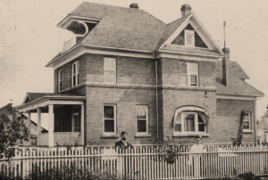
The East Central Neighborhood, established as a working-class suburb before the turn of the century, is one of the oldest in Spokane. The earliest homes were constructed in the late 1880s and the families that settled here were immigrant laborers and railroad workers who were drawn by both the pleasant rolling landscape and easy access to downtown. Between 1900 and 1910, Spokane experienced an explosive period of growth and this boom in the economy and population was felt in both the city core and the outlying neighborhoods. It was throughout this decade that the vast majority of homes in the neighborhood were built, such as the Klein House seen below. During this time of community development, many churches, schools and other public buildings were also constructed, including the stately McKinley School and East Side Carnegie Library. According to one resident, in the good old summer time, the streetcar, the horse-drawn farmer wagons, cabs or carriages would raise clouds of dust like a whirlwind in the Sahara Desert.
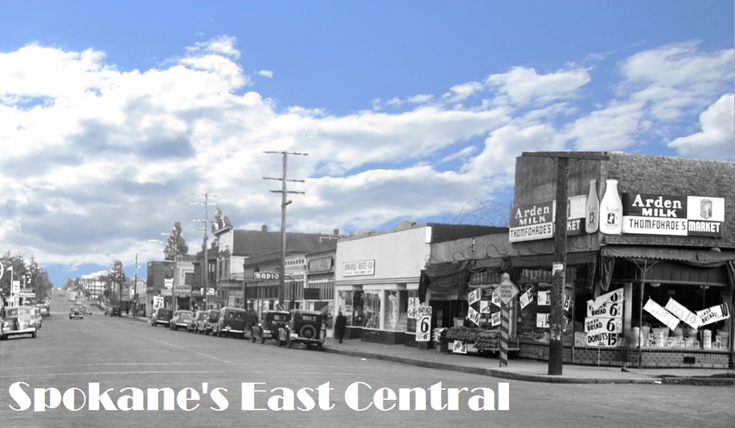
 It was also at this time, in the early 1900s, that the commercial district sprang to life. Many commercial blocks were built along East Sprague, which was quickly becoming a major avenue. Just some of the many businesses that called East Sprague home include tanneries, groceries and delis, hardware stores and a macaroni factory. But by far the biggest industry to arrive to the neighborhood was the Sperry Flour Mill, the iconic silos forever altering the landscape of the neighborhood.
A lot of this commercial success could be attributed to the fact that in 1913, East Sprague was made a part of the Sunset Highway, an officially designated route from Seattle to Idaho. This was good news, as America’s love affair with the car grew so, too, did the need for reliable roads with auto-related businesses. This also meant that property along Sprague was valuable commercial real estate and soon, motor courts, gas stations, drive-thrus and other businesses eager for the motorists’ dollar dotted the roadside.
As the reliance on automobiles increased nationally, the roadways of the country could not handle the burden and in the 1950s, construction of freeways began. The community did not sit idly by while the highway was constructed – the East Side Commercial Club for example was heavily active in fighting for the neighborhood – but the battle was a losing one and by 1965, the Spokane section of the highway was completed. I-90 cut the East Central neighborhood in half, displacing residents, disbanding churches and forcing many of the local businesses to close their doors. (Check out Spokane Historical’s interviews with residents to learn more about the impact of I-90). Regardless of the problems the highway brought, East Central has persevered and possesses a robust community, rich history and unique historic resources.
Now, in the 21st Century, the City has a renewed interest in the protection, restoration and promotion of one of its oldest and most diverse neighborhoods.
The Project
This architectural survey and inventory was conducted by the City/County of Spokane Historic Preservation Office in 2015 as part of an effort to both contribute to and guide the revitalization efforts occurring in the East Central Neighborhood, most notably centered on and around Sprague Avenue. Between 2015 and 2018, the East Sprague Targeted Investment Pilot Area will receive over $50 million in public infrastructure improvements including residential road maintenance and housing rehabilitation. Utilizing a refined approach to economic, community, and physical development, the City intends to revitalize this once-thriving commercial corridor and surrounding neighborhood.
Approximately 778 properties (residential, commercial, light industrial) were surveyed and inventoried in a .5 square miles area; 669 new inventories were created while an additional 109 inventories were updated, mostly for demolished buildings. Several student interns from Eastern Washington University and Whitworth assisted with the surveying, documentation and all the research that is necessary for such a large project: Jessica Bell (Public History), Emily Adams (Urban Planning), Yvonne Lacoursiere (Public History), Joanne Percy (Public History) and Anthony Taylor (Urban Planning). Thanks for all your hard work!
The purpose of this survey was to thoroughly identify, document and contextualize any historic resources within the Targeted Investment Area and the area immediately to the east and to provide guidance in the planning for the wise use of this neighborhood’s unique resources.